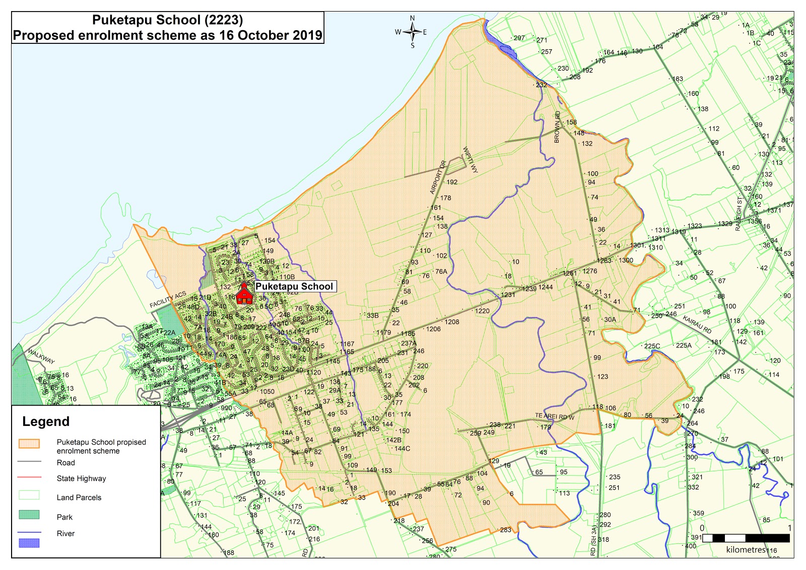
All students who live within the home zone described below and/or shown on the attached map shall be entitled to enrol at the school.
In a clockwise direction, both sides of streets are included in zone unless otherwise stated:
The zone begins at the river mouth of the Waiongana Stream. It follows the river inland (southerly) until it reaches Te Arei Road West. Properties on the western (New Plymouth) side of the stream are included.
From the intersection of the Waiongana Stream with Te Arei Road West the zone follows Te Arei Road West in a westerly direction, crosses over Mountain Road (State Highway 3A) then bears south at the intersection with Ninia Road. Kaipakopako Road is in zone.
The zone follows Ninia Road in a southwesterly direction until the intersection with Corbett Road where it follows Corbett Road in a northerly direction (existing property 204 Corbett Road and all property numbers lower than this are included).
The zone follows Corbett Road in a northwesterly direction to the intersection with De Havilland Drive. Properties on Arthur Road are included.
The zone then follows De Havilland Drive in a northwesterly direction, until the intersection with Mangati Stream. Properties on Vampire Place and Hercules Place are included.
The zone then follows the Mangati Stream in a northerly direction to the intersection with Parklands Avenue. Only properties on the northeastern side of the stream are included.
The zone turns west to follow Parklands Avenue to Smeaton Road. Both sides of Parklands Avenue are included and Acacia Place is included.
The zone turns north onto Smeaton Road. The property at 148 Parklands Avenue is included, 146 Parklands Avenue is excluded. Smeaton Road marks the western boundary of the zone. The zone includes both sides of Smeaton Road. Glamis Avenue is excluded.
The zone follows Smeaton Road in a northwesterly direction until its end, inclusive of the Hickford Park facility access road. From the point where Smeaton Road turns west to become the Hickford Park access road (opposite Parkvue Drive) the zone stops following the road, but continues northwest , maintaining the direction of Smeaton Road to the coast. The zone then follows the coastline northeast returning to the start point at the mouth of the Waiongana Stream.
Puketapu School Enrolment SchemeIf you have any questions about our zone or your entitlement to enrol, please contact the School Office.